What about green zones in Kraainem?
What is the RUP?
“Kraainem is experiencing increasing pressure from urbanization. This pressure can be partially controlled by a spatial implementation plan (in Dutch ‘Ruimtelijk Uitvoeringsplan’, abbreviated RUP), which can guide and limit urbanization pressure in areas and typologies where this is indicated.” Johan Forton Alderman for Heritage and Spatial Planning
There are currently 3 so-called “RUP” procedures in the commune: 1. an “open spaces” RUP
” 2. A “construction floors” RUP
“3. a “flooding” RUP
- How can we protect open spaces?
By formalizing their destination in an “open spaces” RUP.
A case in point is the land known as Pikdorenveld (opposite Delhaize and Carrefour on Avenue de Wezembeek). - The “construction floors” RUP is underway.
This RUP was started in 2010 but never completed.
In 2019, this dossier was taken up by the current political majority.
The next phase is a 60-day public inquiry scheduled to start before the summer vacations.
Once the results of this public inquiry have been processed, the final RUP “construction floors” can be drafted. - The “flooding” RUP – which has not yet been launched – will clarify what can and cannot be built in the area concerned, located in Kraainem Nord near the E40 Viaduct.
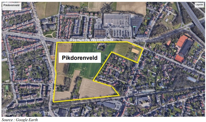
Pikdorenveld – A brief history
- In 2006, a communal spatial structure plan was drawn up (in Dutch ‘Gemeentelijke Ruimtelijk Structuurplan’, abbreviated GRS), the first phase in the development of a RUP), which proposed urban housing projects and additional space for commercial and service activities on the Pikdorenveld.
The plan also indicated that a redevelopment of the Avenue de Wezembeek would be necessary due to mobility problems.
However, the Pikdorenveld field was still (provisionally) indicated as an agricultural zone in the regional plan (in Dutch ‘Gewestplan’). - This unclear situation has led to confusion in the past, with part of the Pikdorenveld even being put up for public sale as ‘building land’ in June 2021!
Fortunately, current mayor Bertrand Waucquez noticed this in time and ensured that the situation was quickly rectified. - As promised at the start of this legislature, the current Kraainem-Unie and Pro Kraainem majority has worked to amend the GRS to confirm the Pikdorenveld as an agricultural zone.
This procedure was initiated at the town council meeting of February 23, 2021 (interesting to note that the DéFi/MR opposition voted against it at the time…) and amended in the GRS at the town council meeting of April 25, 2023. - The next step is to launch an RUP procedure to confirm the non-constructible nature of these plots so that they are also reflected as such in the GRUP (= regional RUP).
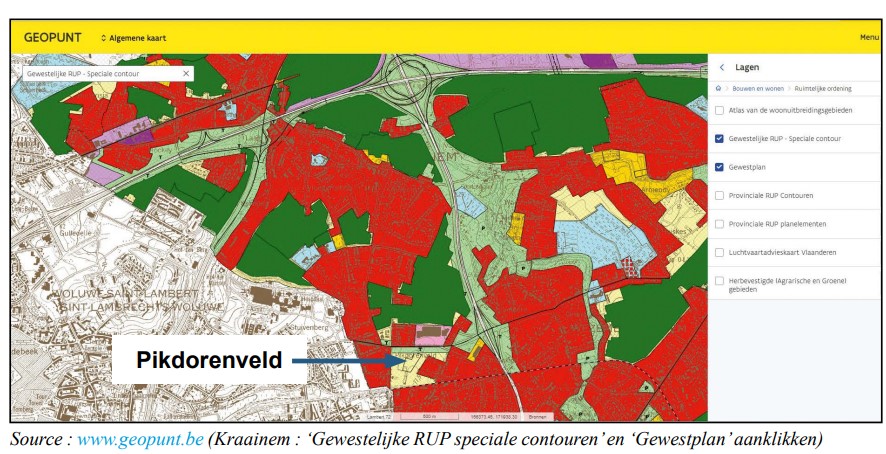
This means that the Pikdorenveld area, currently marked light yellow in the regional plan (see Geopunt map below), will also be colored dark green, i.e. it will be definitively confirmed by the municipality and the province/region as an agricultural area and will therefore remain open space.
Zone destination
The attached map shows the different uses of plots of land in Kraainem.
There are still a few green areas, which we, Kraainem-Unie, are determined to preserve, as several surveys have shown that Kraainem residents particularly appreciate the green character of our beautiful commune! Legend:- Dark green = agricultural zone (Gewestplan), and confirmed in a (G)RUP-Light yellow = agricultural zone (Gewestplan), but NOT confirmed in a (G)RUP-Light green = buffer zone-Red = inhabited zone